


1.Stratigraphic heritages
(1).Stratigraphic section of MCC of Lower Proterozoic Xingzi Group Complex
The stratigraphic section of MCC of Lower Proterozoic Xingzi Group Complex is occurred in two sites,one is in a valley from Xixiansi Temple to Yuanjiapeng,the various schist,leptite,quartzite and marble could be observed along this valley.The other is the section from Guizong to Jinlunfeng Peak,the various leptite,schist and amphibolite(basic lava)are outcropped.The section is complete and naturally preserved.
(2).Stratigraphic section of Pleistocene moraine muddy boulder beds
The stratigraphic section of Pleistocene moraine muddy gravels is best exposed in the Mount Lushan Geopark.The stratigraphic section of Lower Pleistocene moraine muddy boulder beds is in the south of Dapailing Ridge,and the stratigraphic section of Upper Pleistocene moraine muddy boulder beds in Jindingshan Hill and by the Bailongsi Temple near the Poyang Lake.There are many localities for the sections of Middle Pleistocene moraine muddy boulder beds,the most typical one is in Xiaqingshan Hill,the others in Matouzhen,Guanyin'ge and Yangjialin.The section of mixture of moraine and outwash deposit is outcropped in Xingqiao and a hill behind the Chemical Fibre Factory.The section of Upper Pleistocene Lushan-stage moraine muddy boulder beds is located in the valley entrance near the Lulinhu Lake.All these stratigraphic sections above are well preserved.
2.Rock traces
(1).Sedimentary rocks
The Upper Ordovician purple reticulated limestone is good-looking,distributed along a river valley.The Upper Cretaceous alluvial purple conglomerate is spread in beach zone of Poyang Lake,it is complex in gravel composition,it could help to determine the sediment sources.
(2).Pyrogenetic rocks
The garnet-taramite leptynite is originally derived from a magmatite of the upper mantle,it is well preserved in Xiejiashan Reservoir,north of Warm Spring and south of Huangzhaolin Ridge.The Upper Proterozoic gabbro bodies are well exposed in Danoupo Slope and Zixia Peak.The Mesozoic gabbro-diabase dykes are exposed in Xiejialin Ridge and Hengtang,southwest of the geopark.The Mesozoic granite is widely distributed in the geopark.
There are two suites of Neo-Proterozoic volcanic rocks,the lower one is marine volcanic rocks,dominated by spilite,keratophyre,quartz-keratophyre,distributed in the Kangwang Valley;the upper one is continental volcanic rocks,dominated by rhyolite,distributed in crests from the Hanyang Peak to Yuanren Ridge,constituting many peculiar stones of grotesque shapes.
(3).Metamorphic rocks
The Lower Proterozoic amphibolite is widely distributed in the geopark,the garnet-taramite leptite is best preserved in the Laohutan Waterfall and Hongshanwa Waterfall.The leptite is best completely and enjoyably preserved in the Yulianquan and Wolonggang waterfalls and Zuishi Stone.The garnet grains in the garnet-schist exposed in Xixiansi Temple,Huangyan Waterfall are big and numerous,visitors could be easy to find them.There are sillimanite schist in the Weishanlin Ridge and kyanite schist in the river valley near the Changshou Village.
3.Structural traces
The low-angle detachment fault zone at the margin of MCC structure is the major structural trace,best exposed in the Xiejiashan Reservoir,foot of Jinlunfeng Peak,Xianglufeng Peak,Qixianfeng Peak,river valley near Changshou Village,east of Dapailing Ridge,Taohuapu,Dumishan Hill,Wuli River,Liuxingshan Hill and Xiaomushan Hill.The east side of the detachment fault zone is added to the pre-existing left strike slip shear zone.This phenomenon is most typical and distinct along the zone from the Wuli River to Dumishan Hill,the shear zone is composed of granitic and greisenic mylonite.
The plastic fold group is well developed in the Nanhuan sandstone,which is of a fault contact with the underlying Lower Proterozoic complex.The Nanhuan sandstone is just at the northwest margin of the MCC structure.The exposure of this plastic fold group covers a scope of about 500-1,000m wide,and 8,000m long.It is of some value in tourism.A series of detachment faults and corresponding superficial folds in the upper block of the main décollement fault of MCC structure is well exposed in the Beifengkou,Kangjiapo,Dazhaishan Hill,Shimenjian,Zhujiashan Hill and Mazushan Hill.There are two detachment structural windows in the Fuchuanshan Hill and Nijiafan area.The distinct drag folds and angular folds are well preserved in their natural forms in the Shipaishan Hill,Jiandao Gorge,Tianshubi Cliff and Luanlucheng area.
4.Sedimentary traces
The Qingbaikou continental volcanic rock in Hanyangfeng and Xianrenji Peaks is of an unconformity contact with the underlying marine volcanic rock.This is the trace caused by the Neo-Proterozoic plate collision.The Nanhuan tillite(700~680ma ago)was deposited in littoral environment,it could be clearly observed in the Lianhua Cave.The Cambrian Phosphorous-bearing black shale is of a conformity contact with the underlying Sinian siliceous rock,the boundary is clear and complete.
The Bouma sequence in the Neo-Proterozoic turbidite is typical and clear in the Xiaowulaofeng and Zhangjiashan Peaks.The typical scale-shaped ripples and tempestites are occurred in the Middle Ordovician shale in Tongyuan area.
5.Hydrogeolog traces
The maximum flow amount of the Xingzi Warm Spring at the foot of Huanglongshan Peak is 2483t/d.That of the Baochun Spring in Niaoershan Hill and Jinzhu Spring in Haihui is more than 2200t/d.These springs are belonging to the ascending spring in fault zones.
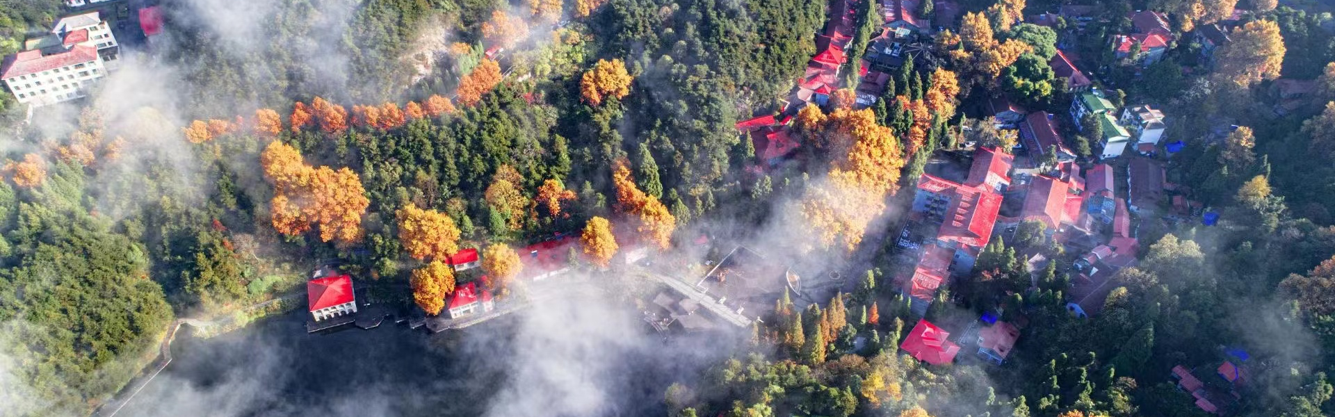
The waterfalls in the Mount Lushan Geopark are famed by their plentiful waterflow,amazing height and wide distribution.The major waterfalls are:Sandiequan,Shimenjian,Huanyan,Mawei,Gulianquan,Yulianquan,Caihong,Baizhangya,Wulongtan,Wangjiapo,Jiandaoxia,Wolonggang,Niaoerya and Jianjiguan Waterfalls.
The rivers in the Mount Lushan Geopark are characterized by large waterflow and torrent current,radically distributed in narrow gorges and valleys.
The Gushanhu,Qingshanhu,Shenlinghu,Luoxinghu Lakes and a part of Poyang Lake are also included in the Mount Lushan Geopark.
6 Geological and geomorphic traces
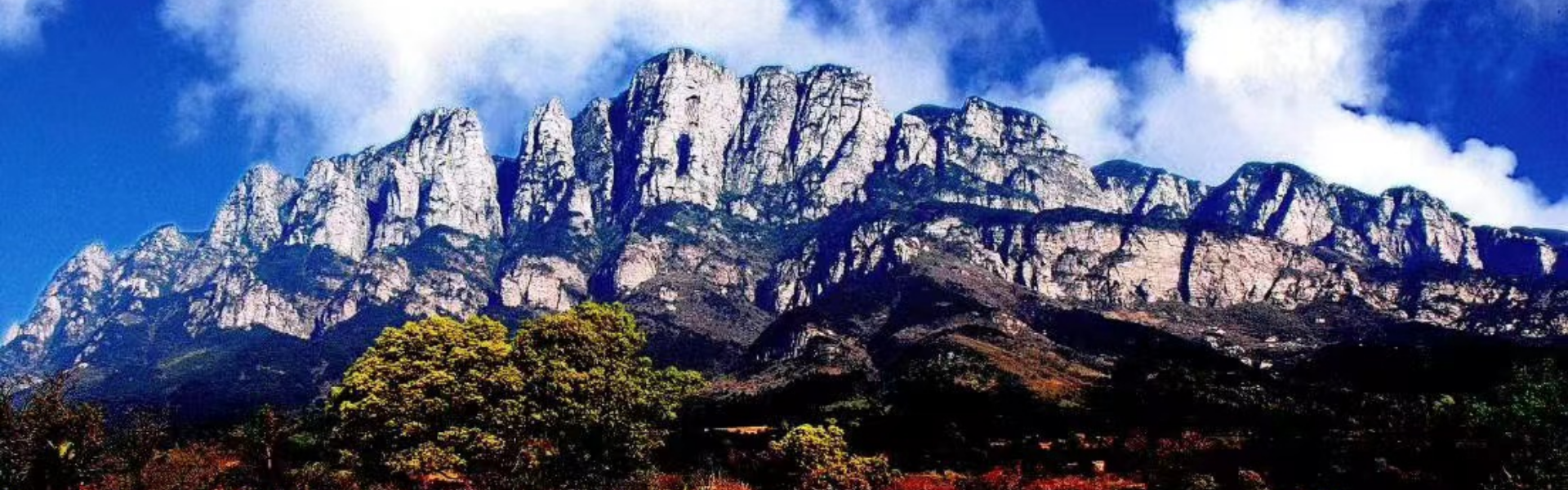
(1).Structural landforms
Major structural landform distribution
| Type
ix = o ns = "urn:schemas-microsoft-com:office:office" />
|
Locality
|
|
| Fault cliff
|
Zhangjiashan,Niaoerya,Baochunquan,Sanwanfan,Tianpaishan,Paitoushan,Longmengou,Guanyinya,Jujiashan
|
|
| Steep cliff
|
Tiebifeng,Shizipo,Longshouya,Shizikou,Jiudieping,Ercengya,Houzishi,Liuyueya,Xingheya,Muguaya,Lingxiaoya,Huangyueya, Hongshiya,Zhaojiangya
|
|
| Peculiar peak&stone
|
Metamorphic rock
|
Xianglufeng,Hemingfeng,Wurufeng,Xiaoshuangjianfeng,Qixianfeng,Maerfeng,Shierfeng
|
| Volcanic rock
|
Jinlunfeng,Banrufeng,Qiaotingfeng,Zixiaofeng,Xiniufeng,Hanyangfeng,Taohuafeng,Shuangjianfeng
|
|
| Sandstone
|
Ruyifeng,Lingxiaofeng,Shichuanfeng,Shizifeng,Jinyinfeng,Pan'gangfeng,Xiangwangfeng, Wulaofeng,Shangxiafeng,Shuangbifeng,Lianhuafeng,Guibifeng,Jinxiufeng,Tiechuangeng,Weiganfeng, Beixianglufeng
|
|
(2).Glacial landforms
Glacial landform distribution
| Type
|
Locality
|
|
| Crique
|
Da'ao,Huanglong'an,Wurusi,Guzizhai,Huangyan,Eyushi
|
|
| Firn-basin
|
Yaowa,Lulin,Sanyixiang,Huanglong,Daxiong'an,Wangjiafei,Baiyunfeng
|
|
| U-shaped valley
|
Wangjiapo,Daxiangchang,Qilichong,Qingliangu,Xigu,Donggu,Shimenjian,Jinxiugu,Jiangdaoxia,Baihejian,Changlongjian, Xiaojiwa,Baishahe,Biyun'an
|
|
| Hanging valley
|
Liangu,Hankouxia,Lulin,Yuelunfeng
|
|
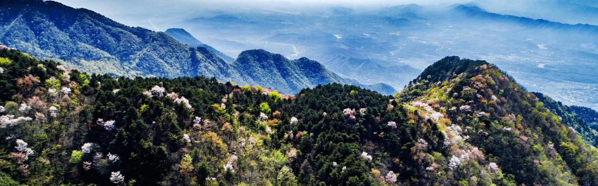
| Crest
|
Dayueshan,Wujiling,Xiaotianchi-Dazhaishang,Nuercheng,Changgeng,Zhujuanshan,Jiuqifeng,Hanpoling,Suozigang,Wulaofeng,Hongshiya,Xianerji, Tiechuanfeng,Tianchishan,Guniushan,Foshouling,Dahuashan
|
|
| Horn
|
Taiyifeng,Litoujian,Yuelunfeng,Rizhaofeng
|
|
| Glacial pavement
|
Jinzhuping,Mumachang,Taiyicun
|
|
| Glacial chute
|
Doumi'ao,Dayueshan,Dazhai,Guandimiao
|
|
| Glacial stairway
|
Shimenjian,Diaoyutan
|
|
| Glacial staircase
|
Baizhangti
|
|
| Glacial spillway
|
Hankouxia,Tianqiao,Lulin
|
|
| Glacial streak stone
|
Zhang'ansi,Jindingshan,Zhangjialaowu Reservoir
|
|
| Ice table
|
Xigu,Haihui
|
|
| Epi-genetic structure
|
Shetouling,Dapailing,Xiaoqingshan
|
|
| Thrust
|
Shitouling,Baishizui
|
|
| Oblique structure
|
Xiaoqingshan
|
|
| Glacial wedging
|
Huangni'an
|
|
| Sheepback rock
|
Hamashi
|
|
| Nose-hill end
|
Xieshan
|
|
| Valley-in-valley
|
Baoguolong,Xue'ao,Lianhuadong,Longmenchong,Huangzhaoling,Guanyin'ge
|
|
| Drift boulder
|
Jindingshan,Daling,Dapailing,Changling,Haihui,Shetouling,Zhoujialong
|
|
| Outwash step
|
Yejialong,Jiulongmiao
|
|
| Moraine section
|
Dapailing-phase
|
Dapailing
|
| Poyang-phase
|
Jindingshan
|
|
| Dagu-phase
|
Xiaoqingshan,Yangjiaoling,Guanyin'ge,Matouzhen
|
|
| Lushan-phase
|
U-shaped valley end of Daxiaochang
|
|
(3).Gorge landforms
There are many famous gorges and valleys,such as the Shimenjian,Jiudiegu,Jinxiugu,Liujiazhai,Pan'ganyuan,Qingniugu,Wolonggang,Qingyuxia,Shijingxi,Kangwanggu,Xiaojiwa,Jiandaoxia and Longmengou.
(4).Caves Traces
There are some eroded sandstone caves:such as Xianren,Shuijing,Mugua and Lianhua Caves,and collapsed caves:Shenxian,Xizi,Wulao,Guanyin,Lingxiao,Ziyan and Liuyue Caves;limestone karst cave,Mazu Cave.All these caves are well preserved and remain in their natural forms.They are of different scientific significance.