


1.The geo-history of geopark
The metamorphic complex of Lower Proterozoic Xingzi Group Complex is exposed in the core of the Lushan Mountain Geopark,its isotopic dating(zircon in lava)is about 1.893~2.180 billion years.During the orogenic event about 1.8 billion years ago,the Xingzi Group Complex was metamorphosed and the crystallized basement was formed in this area.This is the primary continental crust.
During the Mesoproterozoic and Neoproterozoic(ranged from 1.8 billion years to 0.85 billion years ago),the Lushan Mountain area was at the continental margin environment.The plate collision about 850~800ma ago,together with the granitic magma intrusions and eruptions,led to the formation of metamorphic folded basement.The continental crust was formed at that time.
From the Sinian to Triassic period(680 to 220ma ago),this area was a platform stage,dominated by an epicontinental sea.The sedimentary rocks formed during this period become the"Jura-type"folded deformation during the Indo-sinian movement.The Lushan Mountain area became a pitching anticline.
During the Jurassic Period(205ma-142ma ago),this area entered the basin-range development stage,and the crust at that time was in the intensive extending state.Under this condition,the metamorphic core complex(MCC)structure in the Lushan Mountain was formed.The embryonic form of Lushan fault-block mountain and Poyang fault depression lake were formed during the Late Cretaceous.During the Jurassic to Cretaceous period,there were large-scale granite intrusions and a few of basic magma injections.In the late Neogene Himalayan movement,the Lushan fault-block mountain was finally shaped.When the great Quaternary glaciations were occurred,the Lushan Mountain had become a lofty block mountain.
The geological history in the Lushan Mountain area can represent the development history of Yangtze Plate.The continental marginal crust forming stage,platform epicontinental stage,basin-range development stage are of international correlation and geological significance.
2.Stratigraphy
The strata outcropped around the Lushan Mountain area are complete.The Lower Proterozoic stratigraphic sequences are quite complex and hard to put them in a right order.The Mesoproterozic epimetamorphic rocks are derived from a huge suite of flysch interbedded with a few lavas and calcareous slate.The lower part of Neoproterozoic Qingbaikou System is composed of a suite of marine volcanic lavas,and of a suite of continental volcanic lavas in the upper part.
The Precambrian strata are relatively complete in the Lushan Mountain area,with distinct litho-facies constructions.This area is an important window for studying the Precambrian geology in south China.It also provides a rare and precious natural section for studying the continental crust of Yangtze Plate.So the Precambrian strata here are of great value in geology.
The Nanhuan moraine rock is a suite of floating-ice deposits in littoral area,its matrix contains a lot of volcanic ash.It is of significance in international correlation and research.The Cambrian System is of a conformity contact with the underlying strata.The boundary contacts between the Paleozoic and Mesozoic,and also between the Mesozoic and Cenozoic are both conformity.However,the paleontological contents have been greatly changed,they are significant in geology and regional and international correlation.
3.Mineralogy and Petrography
In the amphibolite facies of the Lower Proterozoic Xingzi Group Complex,there are a few lumps of garnet-taramite leptite,ranging from 0.3m to 8m in diameter.The lumps are mainly composed of macrocrystalline garnet and taramite,with some irregular quartz grains.These lumps are isolated in the surrounding rocks and easy to be metamorphosed.The original rock might be the eclogite.The taramite might be degraded from the virescite.The causes,injection pattern and occurrences of these lumps are of geological significance.
In the Lower Proterozoic amphibolite facies,there are several interbeds of amphibolite,composed of basic plagioclase and taramite,the petro-chemical components show that the amphibolite belongs to the island-arc basalt,but not exactly.This kind of basic lavas is of great value for understanding the Paleoproterozoic tectonic environment.
The lower part of Neoproterozoic Jingbaikou System is dominated by the grayish green metaspilite,keratophyre,quartz keratophyre,blastocrystalloclastic sedimentary tuff,with turbidite.The upper part of this System in the Hanyang Peak area consists of a suite of continental volcanic rocks about 1000m in thickness,with a feature of molasse construction.The rocks are mainly composed of basalt,andesite,rhyolite and sedimentary tuff.There is a thin bed of basal conglomerate that is of an angular unconformity contact with underlying strata.The continental volcanic rock is the product of plate collision.The rocks in the Upper Proterozoic volcanic series are specific,they are of important significance in petrology and mineralogy.
4.Structural geology
The center of the Lushan Mountain Geopark is the MCC structure that was formed during the Jurassic to Cretaceous period.The inner core is composed of the MCC of the Lower Proterozoic amphibolite facies.There are many multi-level dismantled faults and corresponding epigenetic and plastic folds on the upper block of the main décollement fault.In addition,there are a series of folded layers and penetrative slip cleavages in the epimetamorphic rocks.Such various patterns and styles of the extending structure are rare,especially the well-developed plastic fold group in unmetamorphic sandstones.Their structural features are of great scientific and international correlation value for understanding the forming process of the MCC extending structure.There are a lot of simultaneous granite intrusive bodies in the central area of the inner core.To study the genetic relationship between the granite intrusive bodies and MCC is a crucial way to understand the cause and evolutionary role of the intraplate extending structure.
5.Hydrogeology
There are 20 rivers and streams on the Lushan Mountain,roughly in a radical distribution.The upper reaches of most rivers are located in narrow gorges,most of them form waterfalls with plenty of water.The highest waterfall is about 155m high,its roaring could be heard 3km away.Each waterfall begins with a crack mouth and ends with a deep green pool.The largest freshwater lake of China-Poyang Lake is a typical and rare river-connecting lake,with a total area of 5,500km2.The Poyang Lake is also a seasonal lake,its water capacity would be varied greatly(more than ten times).The Yangtze River,the longest river in China is just wandering through to the north of the geopark.The width of the river is up to 1.5km.Due to the river shift,there are a series of potamogenic lakes on both sides of the Yangtze River.
The Xingzi warm spring in the Mount Lushan Geopark has been developed for over 800 years.Its surface temperature is 62℃,the maximum flow amount is up to 2483t/d.It has a lower mineralization intensity(340mg/l),the pH value ranges from 7.8 to 8.6,each litre contains F 15mg,H2S 4.25mg and Rn 51EM.It is a typical H2S-Rn spring.Its quality could be compared with the Bass Spring in Europe.
It is very rare that so many water landforms gather together in a single geopark,especially for the various and colorful waterfalls and warm springs.The hydrogeological features are of great scientific significance.
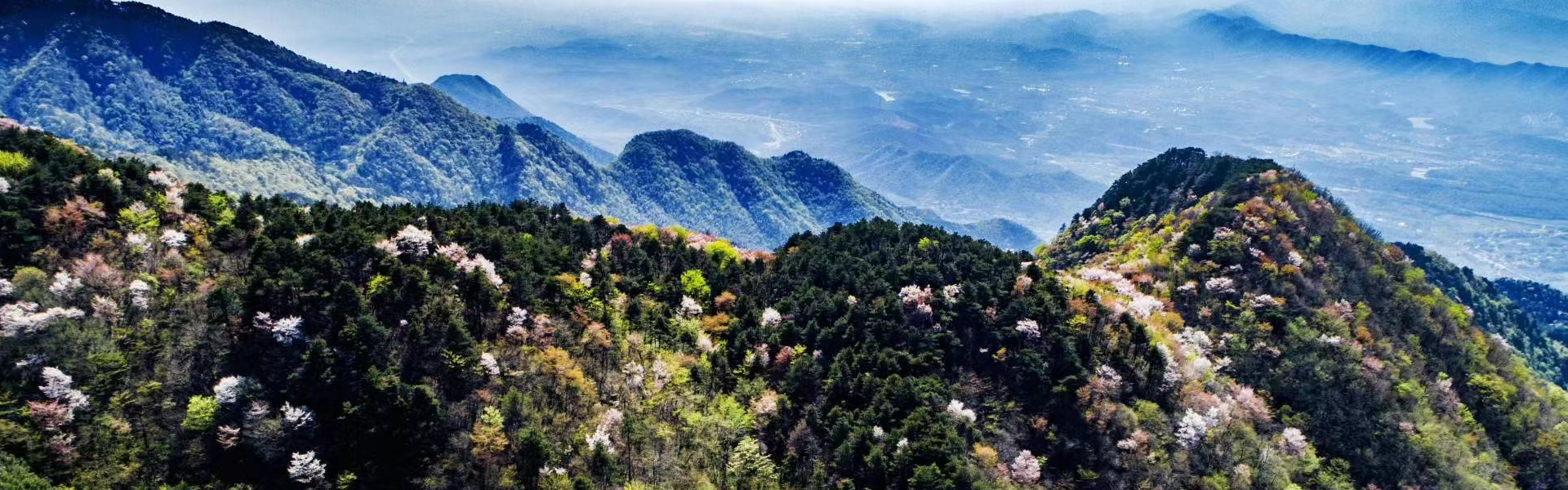
6.Geomorphology
The Lushan Mountain has a specific geomorphic feature,composed of the fault block mountain,glacial erosion and flowing water landforms.
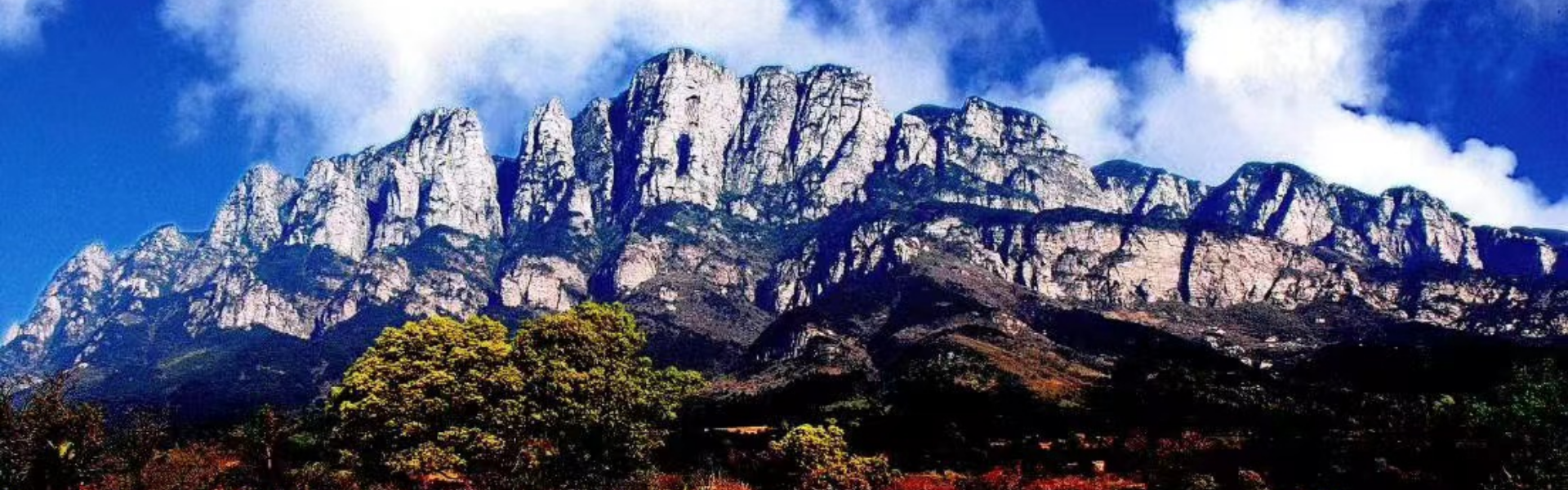
The fault-block mountain landform in the geopark is unique,its west side is the fault boundary cliff of high-angle normal fault,and the east side is the cliffs of the vertical shear joint surfaces.
The Quaternary glacial erosion landform is another unique landscape in the geopark.This maritime mountain glacial erosion landform was formed on the basis of asymmetric block mountain.As the block mountain kept uplifting,the glacial erosion was intensified,so the crests are extremely developed in the Lushan Mountain area,these crests are hacksaw,showing a peculiar peak forest.The glacial U-shaped valleys and firn-basins are relatively well developed between each pair of crests.It provides a natural place for relaxation and vocationing.
There are two sets of X-shaped vertical shear joints universally distributed in the rocks within the geopark,it is easy to form cliffs and narrow gorges under the exo-and endo-dynamic processes.Especially at the end of glacial time,as the crust kept uprising,the flowing water erosion became intensified,the collapses along the vertical shear joints were frequent,so the narrow gorges and cliffs were occurred in most of U-shaped valleys.Together with the primary glacial staircases,the beautiful waterfalls are extremely developed in the Mount Lushan Geopark.
The combination of block mountain,glacial erosion and flowing water landforms is more unique and rare,it is of great value not only in geomorphology,but also in the tourism.
7.Quaternary Glacial Geology
The Mount Lushan Geopark is the most typical locality of Quaternary maritime mountain glacial vestiges at the middle-latitude mountain area in the east China.The glacial erosion landforms are complete and visible,such as cirque,horn,crest,U-shaped valley,hanging valley and firn-basin.The evidence for glacial movement is clear,such as glacial pavement,striae,streak,drift boulder and epigenetic structure.The lateral and terminal moraines are developed.The glacial deposit is typical,being a mixture of moraine and outwash sediment.
The Quaternary glaciers in the Lushan Mountain could be well compared with the glaciers in Alps area,but they have their own specificities.The Quaternary glacial vestiges in the geopark are of important significance in geological research and international correlation.It is a crucial area for understanding the Pleistocene paleogeographic,paleoclimate and paleoenvironmental evolution in east China.